The TCDI System builds on all the major modules of our Traffic Collision Database in the areas of locating, inputting, verifying, and querying, while providing a seamless integration between the database and GIS mapping software.
Key database components used to accomplish these tasks are the Existing Streets Table, the Street Layout Table, and the Data Verification Module. Producing an accurate TCDI requires the ability to verify the street name information for each location. The system resolves conflicts by keeping a table of all actual street names in the city along with a street layout table, which defines the relationship of streets in the system by storing the distance and direction between adjacent intersections. One additional table, the Street Alias Table, is used to store common misspellings and abbreviations. The system uses these tables to verify and correct all the information for each traffic control device entry.
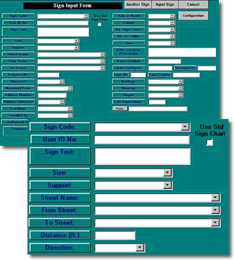
The TCDI system employs intuitive, easy-to-use data-input screens that feature drop-down lists to allow users to select from standard entries; this, along with other features, facilitates all aspects of data input.
The data input forms are thorough, complete forms for tracking and managing control device information. For example, the sign inventory provides the following data entry fields for inventory purposes: sign message text, side of street for sign placement, direction of sign, inventory date, date installed, date of last replacement, cross street or cross reference location, distance and direction from reference point, sign dimension and support type, sign face material, sign backing material, and much more.